This summer I was blessed with the opportunity to take a geology class on the northern Rockies that took place in the northern Rockies! It was incredible. Having lived all of my 21 years on the East Coast, it was a whole new world. A world that for two weeks was filled with breathtaking views, incredible hikes, and a history that can’t properly be put into a museum. I’m talking about the history of the very landscape itself. Every day we would stop at numerous rock outcrops to learn how these rocks formed and came to be where they are today. In many places the rocks would be so faulted, overturned, and inclined, that I was amazed at the brutal history they must have endured to have arrived at their present day state. However, this wasn’t what we found when we traveled to Glacier National Park.
I am so thankful my first visit to Glacier National Park was during this course because not only is the park stunning in its beauty, but it has so much to offer in terms of geology that my untrained eye would not have understood before this trip. The area is structurally fascinating in its simplicity and yet extensive history; like the name implies, the park is an amazing place to see the effects of glaciation; and hiking to places such as the Grinnell Overlook provided us with the chance to see stromatolites, mud cracks, ripple marks, the Purcell Sill and more up close and personal.
Glacier National Park in Montana is part of the famous Belt Supergroup that contributes to the Rocky Mountains in Western North America and Canada. The Supergroup consists of sedimentary rocks deposited during the middle to late Proterozoic. The rocks were deposited when a rift formed between continental land masses. This rift subsequently formed an intra-cratonic, subsiding basin filled in by shallow seas. Eventually the rocks were buried and lightly metamorphosed. Today, these ancient Precambrian rocks can easily be seen in Glacier National Park due to the low-angle thrust fault called the Lewis Overthrust. During the Sevier orogeny, the Precambrian rocks were compressed and forced to slowly move over 50 miles eastward as a huge thrust sheet (15 to 20 kilometers thick) overtop of softer Cretaceous shales. Evidence of this thrust fault can easily be seen when looking at Chief Mountain, a klippe or an erosional outlier, that is located at the park’s eastern border. Chief Mountain stands alone and is reduced in size because it has been eroded from the rest of the thrust sheet. At the mountain’s base lies the Cretaceous shales while the upper portions consist of Altyn, the oldest formation within the Belt Supergroup.

There are eight formations within the Belt Supergroup (from oldest to youngest): Prichard, Altyn, Appekunny, Grinnell, Empire, Helena (or Siyeh), Snowslip, and Shepard. During our trip, we saw the Altyn, Appekunny, Grinnell, and Helena formations. Altyn and Prichard are actually the same in age but were deposited in different environments. The Belt Basin slopes to the west, so Prichard was deposited in the deeper parts of the marine environment while Altyn was deposited in the shallow eastern marine environment. Because of this, the Altyn formation is made up of light-grey, tan colored limestone and dolomite with quartz and feldspar while Prichard consists of dark grey siltite and argillite. Above the Altyn and Prichard formations, lies Appekunny. The Appekunny formation is made of greenish gray siltite and argillite. This layer is dominated mostly by lithified mud. As layers of rocks kept being added to the Belt Basin, the basin continued to deepen. The Appekunny formation added so many sediments, the ocean that filled the basin became a broad tidal flat. When the Grinnell formation was deposited, the siltite and argillite formed a brick-red color due to the abundance of oxygen in the shallow waters. The oxygen allowed the iron within the sediments to oxidize into hematite. After the Grinnell formation, the basin began to further subside, thereby changing the depositional environment. During this transitional period, the Empire formation was deposited. This rock unit is mostly greyish green with a little red and consists of siltite, argillite, and some carbonate beds. Overtop of Empire, lies the Helena or Siyeh formation. This formation consists of limestone and dolomites and has some awesome features due to the shallow, warm waters and decline of mud and silts into the basin. I will talk about some of these features later on! The last two formations are Snowslip and Shepard. These two units have mostly been weathered away but can be found at some of the park’s mountain peaks. The Snowslip formation has red and green argillites, yellow quartzite, and purple siltstones, while the Shepard formation has red and tan limestone, dolomite, and siltstone.
Here is a cross section of the park, to help visualize all this information:

After the deposition of the Precambrian, Paleozoic, and Cretaceous rocks and the erosion and thrust faulting that ensued, the Pleistocene glaciation entered the scene. During the middle Pleistocene, there was extensive glaciation throughout the park. The valleys and divides that had begun to erode due to the presence of rivers and streams were further eroded by glaciers in a more rapid and severe fashion. Glaciers carved out U-shaped valleys, aretes, horns, cirques, hanging valleys and more.
Now I will show you some of the cool features we saw along our hike to Grinnell Overlook!
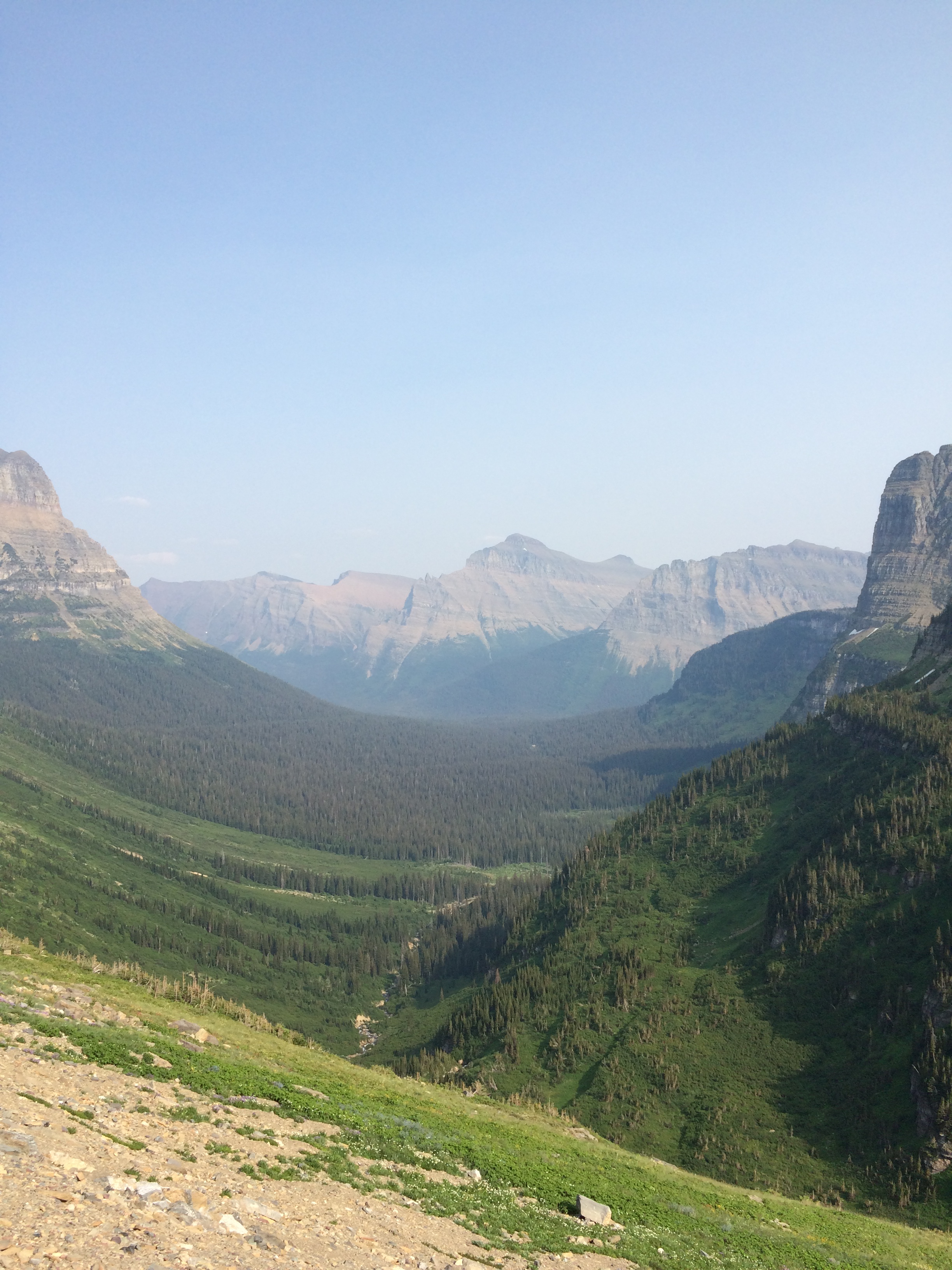
Here is a quick look at a portion of Glacier National Park. The dotted red line is the trail we took.

As you can recall from earlier, the rocks deposited in the Belt Basin were in a marine environment. I found that I constantly had to remind myself of this fact because it can be easy to forget when you are at an elevation of 6000 feet. However while hiking, we found that the rocks held clues to their ancient environment. In the picture below you can see mud cracks in some rocks of the Grinnell formation. These cracks indicate that at some point after deposition into the shallow waters of the Belt Basin, the wet sediments dried out in the sun. So very very long ago, these sediments were above water level, and we can still see evidence of it some 1600 million years later!

Many of the bedding surfaces also show evidence of ancient currents and waves in the form of ripple marks on the rocks. Here we see some very prominent ripple marks in more of the Grinnell formation.

When glaciers move over rock, they cut into it and produce an incredible amount of debris. These cobbles, boulders, gravel, and sands are called till when unsorted, but when they accumulate they can form moraines. The last stretch of our hike was actually through moraine that has accumulated in front of Grinnell and the Salamander Glaciers. Moraines can also form natural dams. One of the lakes we hiked past, Lake Josephine, is an example of one of the many lakes in the park with moraine serving as a natural dam.

You can also see in the photo above a classic example of a U-Shaped valley! When streams cut through valleys they tend to form a V-shape. But when glaciers make their way down valleys, they cut through the sides of the slopes, steepening them, and deepening the valley floor in the process. Here is another U-shaped valley seen on the Going-to-the-Sun Highway.
During our hike to the overlook, we passed several beautiful lakes. Once we reached the overlook, we could look down into the valley and see a string of lakes and streams leading up to the glacier. This series of lakes connected by a stream is called a paternoster lake. These can commonly occur in alpine valleys because they are created by end moraines that have advanced and retreated. Paternoster is the name for the Lord’s Prayer and is Latin for “Our Father”. It is so called because the lakes connected by a stream resemble rosary beads on a chain.

Let me just tell you, this hike was definitely not the easiest hike I’ve ever been on, but it was the most beautiful. It was well worth the effort as every step of the way is breathtaking (doubly challenging when trying to catch your breath). Once you finally reach the top, you are greeted with the sight of Upper Grinnell Lake, Grinnell Glacier, and The Salamander. Grinnell Glacier was discovered in 1885 by George Bird Grinnell, and he was so taken by the area that he worked hard to help make it a national park. Unfortunately the glacier is melting fast. It has already lost 90% of the volume it had when it was first discovered.

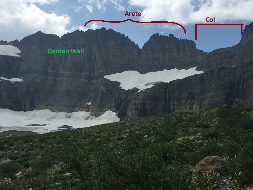
As you probably noticed, there is a lot more going on in that last picture than just two glaciers! First let’s take a look at what the glaciers are situated on. This is part of the Garden Wall which is an arête. An arête is a thin wall of rock in between where two cirques have eroded back to back. The Garden Wall also has a col, or a saddle shaped depression where glacial ice broke down the arête.
Because the glaciers are melting at such a rapid rate, they have created a proglacial lake in front of them that is dammed by the moraine. The water in this lake and the downstream paternoster lakes has a beautiful turquoise color that is in part due to particles from the surrounding rock, called rock flour, that has settled in the water.

I have to say Glacier was surprisingly comforting in the most unexpected way. While driving or hiking through the park, I could always get my bearings and help determine what formation I was looking at based on the ever present sill in the Helena formation. As I’m sure you have noticed in some of the other pictures, there is a conspicuous dark igneous intrusion bordered in white. The sill, which is known as the Purcell Sill, is on average 100 feet thick and is composed of diorite. It is thought to have injected into the Helena formation around 775 to 725 million years ago. The white border was created when contact metamorphism “bleached” or “baked” the surrounding limestone. The furthest edges of the sill cooled rapidly upon contact with the limestone, giving it a fine-grained appearance. Because the middle of the sill cooled more slowly, it has a coarser texture.

Here is an up close and personal look at the sill:

Here is another with my fellow classmate Josh for scale:

While lounging by the proglacial lake, our professor pointed out an offshoot of the intrusion. Here you can see it behind my friend Peri,

Now, I saved my favorite for last. I have to say I did not fully appreciate these until I was quite literally sitting on top of them.

Pretty cool looking right!? What you are seeing is part of the reason our atmosphere has oxygen today. They are the fossilized remains of stromatolites. Limestone precipitating cyanobacteria thrived in the shallow, warm waters of the Belt Basin after the Helena formation was deposited. They lived in mat-like colonies, and when they precipitated layers of limestone, they would grow closer to the surface of the water. This was critical as they depended on sunlight in order to remove carbon dioxide from their surrounding waters and release oxygen and calcium carbonate. These fossilized stromatolites thrived during the Proterozoic, but they can still be found today in certain climates protected from predators such as snails.
Here is a picture of Zach appreciating them:

Some of my classmates posing with the stromatolites:

I cannot express enough how incredible this experience was. Part of the reason it was so great, was because I was able to see and learn about things I had only read about in textbooks. If you have the opportunity to visit Glacier National Park, please take it. I hope this post helps you identify and further appreciate all this wonderful park has to offer.
Happy travels!
